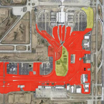
Situated on 52 square miles of prairie land along the front range of Colorado, Denver International Airport has an invasive weed problem. Ensuring the safety of the nearly 6 million passengers who travel through the airport each month means controlling the spread of these weeds to keep the runways clear.
Despite being the fifth busiest airport in the country, DIA has a restricted budget for vegetation management. In the past, they have relied on mowing as their primary management strategy. This approach is both time consuming and resource heavy. Additionally, a high rate of turnover amongst their staff has made it difficult to maintain an effective management strategy year over year.
Rachel Seedorf suspected that the challenges facing organizations like DIA could be addressed by establishing a precision-directed land management program. If such a program was comparably effective to a total land restoration project in terms of controlling weeds, it could return significant financial and resource savings. Using DIA as her test subject, Rachel turned to SprayLogger and MapItFast for the solution.
Rachel Seedorf is a Masters Student in the Colorado State University Weed Research Lab. For her thesis work, Seedorf developed a targeted invasive weed management program at Denver International Airport. Seedorf showed that even lacking the resources to maintain a year-round land management program, organizations can create effective restoration plans using GIS technology such as MapItFast and SprayLogger.
Phase 1: Mapping a Management Plan
The Colorado State University Weed Research Lab initially purchased MapItFast and SprayLogger from AgTerra to for a project involving GPS tracking of pesticide applications near sensitive cropland. Recognizing the ease of use and affordability of AgTerra’s products, Seedorf realized that she could also use these tools to aid in her thesis project.
Under the direction of Scott Nissen, a Weed Science Professor and Extension Specialist at CSU, Seedorf outfitted a UTV with a SprayLogger E3B unit and deployed it to the airport grounds.

The first year of the project consisted of initial mapping and treatments on the property to understand the scope of the program that would be needed. In formulating a management plan, Seedorf faced a challenge of dealing with inconsistent records from previous programs. MapItFast helped her surmount this challenge by allowing her to quickly survey, map and record test treatments of the property.
These initial records formed the groundwork for future applications. MapItFast was key in the initial investigation and applications as applicators were able to GPS and draw points, lines, polygons and geo-photos from the app or desktop to create a detailed map of the area with corresponding reports.
“Being able to go into the MapItFast system and easily click on a point, line or polygon…. being able to GPS where we had been and take notes… all of that was super user friendly…. Drawing polygons for area estimation was great. It helped us determine how much product should be used for applications.”
Rachel Seedorf, M.S. Student in the Colorado State University Weed Research Lab

Phase 2: Creating a Targeted Noxious Weed Application Plan
Once the first year was complete, Seedorf took the resulting data and maps and put together a plan for a targeted treatment approach. In addition to providing simple points, MapItFast and SprayLogger provided the distance and area of previous application sites. This helped her estimate how much product and time would be needed for future work.
Using the data gathered with MapItFast and SprayLogger, Seedorf was able to identify 40 priority treatment strips and create an application schedule for the next season. The plan gave applicators a detailed map of where they needed to go and maximized their time by allowing them to pass over areas that did not require treatment. As a result, a single applicator was able to treat all 40 strips in one day. This is in comparison to the existing mowing plan, which involved multiple mowers operating over multiple days.
“To have that information logged… to see who sprayed what and when… for a group like DIA who do not have a year-round program, that information would be extremely useful,”
Scott Nissen, Weed Science Professor and Extension Specialist for CSU
The Result: Cost Effective Land Management
The project showed that groups with limited resources and high staff turnover can still have an effective land management program by making effective use of electronic mapping and data collection systems. AgTerra’s Pesticide Application Tracking system provides a complete record keeping solution at a fraction of the cost of a full land management program. With cloud-based record keeping and the ability to store previous project and job data, new users pick up the program and move forward without having to start from scratch every year.
Seedorf submitted her work to DIA, and she hopes an understanding will be gained by the airport and others who read her thesis that a targeted land management program can be effective without the need for a permanent staff. Both Seedorf and Nissan believe that utilizing and customizing the additional tools that AgTerra offers, such as Strider Forms and Reports, will make the planning and execution of future programs even more effective for the target organizations.