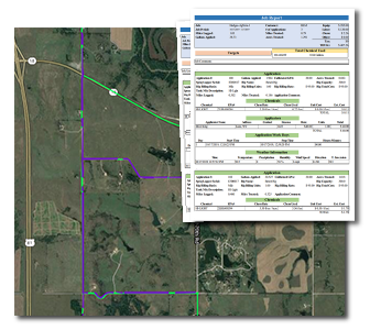
Kenny Baccus is the Weed Director for Ottawa County, Kansas. His job takes him all over the county to document and control the spread of weeds. But it also takes him into the County Commissioners’ board room and occasionally the courtroom, where MapItFast and SprayLogger combine to provide an invaluable tool for proving the accuracy of the work he and his staff does.
Liability Protection in ROW Weed Control
The Ottawa County Weed Department is responsible for maintaining 2100 miles of county road right-of-way. All across Kansas’s 105 counties, county roads pass through highly sensitive crop lands. Baccus’ interest isn’t just in keeping the ROW clear for traffic; he’s also got to think about the potential economic impact of mistakes such as spraying in the wrong area and pesticide drift.

This means precision application is a must, but so is precision reporting. When the County receives a claim that their weed control work has impacted a farmer’s crop yield, they need to be able to document exactly where they sprayed and – as importantly – where they didn’t. Hand drawn maps and notes jotted down from the cab of their truck just won’t cut it.
SprayLogger takes all the guesswork out of spray application tracking, providing automated maps and reports of all spray activity including exact GPS coordinates for active spray lines and area traveled when not spraying. SprayLogger reports also include weather conditions and chemical amounts, all laid out in a professional, printable format.
When he provides his commissioners with SprayLogger reports he ensures their confidence that he is protecting the County’s interests.
“We deal with a lot of liability issues as far as spraying right-of-ways and dealing with sensitive crops such as soybean and cotton. Mapping is the thing that I really push on other counties when they’re looking into a spray system. To really pinpoint where we’ve been, what we’ve sprayed, and what we haven’t sprayed.”
Kenny Baccus, Ottawa County Weed Director
Noxious Weed Surveying and Investigation
The Kansas Noxious Weed Law requires Weed Directors like Baccus to perform a yearly survey of weed infestation in their county. In addition, they are responsible for investigating failures to control infestations on private land. Ultimately, Baccus reports violations to the County Attorney, and he might find himself in a courtroom offering testimony on discoveries of uncontrolled weeds.
Baccus uses MapItFast to conduct his weed surveys. He maps points and polygons to indicate infestations and takes geophotos right from his mobile device. He informs landowners of problem areas he discovers. Then, in his investigative capacity, he can return to the exact location to document eradication efforts. MapItFast keeps all his survey data in order. If the landowner has failed to undertake appropriate control measures, Baccus has before-and-after proof. This makes the County Attorney’s job easier and secures much better response to infestation notifications among landowners in his county.
“If landowners have a problem of noxious weeds that they haven’t taken care of, I go out and map it and I’m able to print out those maps. I’ve also taken photographs through MapItFast of problem areas of noxious weeds and I attach them to the map. That way commissioners can see it personally, or if I have to take it to court, I can bring it up on the projector and show those areas with the picture. It just works for me for legal reasons.”
Kenny Baccus, Ottawa County Weed Director

Taking It to the Next Level
The reliability of the maps and reports that Ottawa County gets from MapItFast and SprayLogger have provided a significant return over their previous program just in terms of liability protection and prosecution of violations to Kansas’ Noxious Weed Law.
Baccus is excited to explore AgTerra’s mapping and record keeping system further to find even more ways to improve his operations. Here are just a few ideas he has for the future:
- Work with SprayLogger’s built-in STAR Weed integration to document and report their chemical inventory and invoicing.
- Integrate job data from SprayLogger into his MapItFast projects to inform new staff members of key treatment areas and show his commissioners how their control efforts have mitigated particular infestations over time.
- Help with the Weed Department’s responsibility of monitoring county 911 road signs for vandalism. Baccus has already started using a MapItFast project to mark road sign locations and attach notes and photos of damage they encounter.
- Delve into the Strider form builder to create forms and reports so he can send infestation notifications to land owners instantly from his mobile device.
- Upgrade his SprayLogger units to implement split-boom mapping and reporting. This way, he can get even more precision by tracking activity from each of his booms independently.